• Dan Kelleher, PG, CIPM, Hydrogeologist and Principal, Midwest GeoSciences Group
Workshops Featuring:
Geologic Settings of the Mid-Atlantic and Coastal Plain Areas Soil Sampling and Rock Coring through Saprolite Contrasting Soil Classification Systems: Meaningful Standards Reading the Story the Sediments and Saprolite are Telling Strategies for Efficient Field Task Management Strategies for Managing Unanticipated Site Conditions Taking the Mystery Out of Sedimentary Heterogeneities & Uniformities
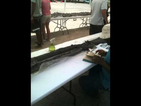
Soil Core Logging Exercise from Past Course
Continuing Education Information:
1.6 Continuing Education Units (CEUs) (16.0 Professional Development Hours)
Continuing Education Units (CEUs) and a Course Completion Certificate will be administered by the West Chester University. Most state professional licensure programs accept CEUs for this course.
PENDING FOR: Connecticut Licensed Environmental Professionals Massachusetts Licensed Site Professionals Delaware Professional Geologists South Carolina Professional Geologists New Jersey Licensed Site Remediation Professionals
Who should attend:
Professional ground-water scientists, engineers, project managers, compliance-program managers and remedial-design managers characterize complex soil sequences, relate geotechnical properties to the site-specific soils, understand groundwater flow through the sequences, and install dependable groundwater monitoring systems.
How to Prepare:
Be prepared to immediately dive into a series of lectures, workshops and self-tests that are designed to help empower you unravel subsurface complexities like no other course. We start at the beginning and boldly address the challenges we all face in our profession...and then move into principles and strategies for managing subsurface uncertainties for ground water and geotechnical projects.
Bring your clipboard, a pen, a calculator and we will provide the rest to facilitate your participation during indoor and outdoor workshops.
Dress for field variable field conditions. Hard soled shoes are required. A exclusionary work zone will be established around the drilling rigs for safe. Do no entery the exclusionary work zones.
Liability Release:
Each participant will be required to review and sign a release of liability in order to register for this course and workshops.
Spectators:
Unannounced visitors and spectators are not permitted in designated the field workshop areas. There is no parking available in the field workshop areas. A shuttle will transport people from a parking lot to the workshop area.
Course Details
Why You Want to Attend:
The best place to learn site characterization is in the field. This two-day field workshop addresses how to deal with common uncertainties encountered in hydrogeologic and engineering projects using complex saprolite sequences as an example.
The workshop includes real-time drilling, sampling and testing of saprolite on campus at West Chester University, with discussion of the (1) basic geologic principles needed to understand saprolite sequences, (2) effective field techniques, (3) how to read the story that the soil cores show, followed by (4) discussions on making field decisions and (5) managing uncertainties and unanticipated soil conditions
This is the only course that teaches the principles and field techniques of how depositional environments and weathering zones play a role in hydrogeologic and geotechnical investigations.
Get more from your existing borings instead of always wanting more.
Applying Basic Geologic Principles to Solve Complex Issues
Managing complex soil sequences begins with applying basic geologic principles. Unfortunately, field staff are often too busy with field screening, collecting environmental samples and/or sometimes just not equipped or experienced to recognize key geologic indicators that can help unravel hydrogeologic and geotechnical complexities.
This field workshop begins with a brief overview from the Part 1, Principles course. Then we progress deeper into field techniques for various soil conditions. At the drilling site, we will encounter a complex saprolite formation with varying degrees of decomposition and disintegration. We will also address different depositional environments to help empower staff with field analysis tools.
Advancing Field Techniques with the Right Technologies
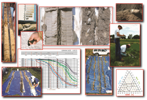
Thanks to the drilling company, we will continuously-sample multiple soil cores through saprolite and conduct a series of analyses and correlation exercises. While good sample recovery and resolution is important, it's also crucial to recognize key geologic indicators.
This field workshop helps develop observational skills and the interpret of various sedimentary attributes and secondary weathering alteration. Sample management will be illustrated during the field component where the deep soil core will be displayed from end-to-end helping us read the sedimentological story.
Reading the Sedimentological Story
Field techniques are important and can make or break a project. While characterization technologies are related to field techniques, how and when we analyze the field data is critical for reproducible project success. And fortunately, the analysis process can generally be simplified with some easy-to-implement sample management techniques, accurate and complete boring logs, and a step-wise procedure for giving geologic context to project requirements.
This field workshop helps improve analysis and synthesis of field observations along with time management of critical field duties. Too often, field staff are overloaded with field tasks. A dialogue with participants helps reveal strategies for efficient field management of analysis, logging, sampling, well installation, and correlation.
Making Sound Field Decisions
Subsurface conditions are sometimes not what we expect to find. For those moments it helps to have staff who are capable of knowing what questions to ask, when to ask them, and make sound field decisions.
This field workshop challenges participants to think about how the sediment relates to project objectives. For example, how do we relate subsurface variabilities (heterogeneities) to preferential ground-water-and-contaminant pathways using geologic knowledge, understanding and experience? We will also tackle the inefficiencies and uncertainties of popularly prescribed environmental sampling methods.
Managing Uncertainty and Unanticipated Conditions in the Field
Uncertainties and unanticipated conditions are frequently encountered while investigating complex soil sequences. This 2-day workshop is designed to empower professionals to recognize unanticipated field conditions and manage them in a logical and reliable way.
This workshop includes a session devoted specifically to recognizing and managing these unanticipated conditions and uncertainties, including how to avoid the misuse of certain principles and techniques.
Registration
REGISTRATION INFORMATION:
Limited registration.
Advanced registration is necessary for participation in this limited-enrollment short course. Pre-registration is required to reserve space and receive course materials. If you require special arrangements for diet, equipment, or handicap facilities, please indicate when registering for the course.
Register online for this course.
WHAT YOU WILL RECEIVE:
Participants receive 16.0 contact hours of instruction, Course Notebook, a FIELD GUIDE FOR SOIL AND STRATIGRAPHIC ANALYSIS, course completion certificate from West Chester University, continental breakfast, morning coffee break, lunch, and an afternoon break.
This course is uniquely designed with lectures, workshops, and exercises that create a meaningful learning experience from senior managers to entry-level field staff.
Calibrated soil samples are used in the course to demonstrate not only differing (USCS and USDA) classifications, but some key grain-size boundaries to illustrate the precision of soil classification. [A few extra batches of calibrated USCS and USDA soil samples are prepared for this course and will be available for purchase with your registration].
REGISTRATION:
Early Registration Fee: $598.00
Government Registration: $498.00
(call 763.607.0092 to receive a govt discount)
FREE FIELD GUIDE FOR SOIL AND STRATIGRAPHIC ANALYSIS with each course registration
OPTIONAL ITEMS:
The online registration allows registrants to add items to their course registration.
Item No 1: Full-Color Course Notebook for $89.00.
Item No 2: MIDWESTGEO USCS / USDA CALIBRATED SOIL KIT Add-On for $189.00.
EARLY REGISTRATION DISCOUNT:
Early registration discounts may be applied when payment is received by August 31, 2018. Terms and Conditions apply.
CANCELLATIONS:
Cancellations may be made up to September 5, 2018, however, 50 percent of the course fee will be charged or a credit will be issued. No refunds. One substitute is allowed for each registrant who is unable to attend.
QUESTIONS:
Technical Questions: For registration and technical questions about the course, contact Dan Kelleher at either 763.607.0092 or dan@midwestgeo.com
Instructors
MARTIN H. HELMKE, PG, PhD Martin Helmke is an accomplished hydrogeologist with over 20 years experience as an educator and environmental consultant. Before joining West Chester University, he taught at Dickinson College, Iowa State University, Antioch College, and Directed the Geology Field Camp for Iowa State University and University of Nebraska in Shell, Wyoming. He has worked for the U.S. Geological Survey (Reston, Virginia), Versar (Springfield, Virginia), HydroLog (Yellow Springs, Ohio), Boyden Caverns (Kings Canyon, California) and Aquadrill (Coralville, Iowa).
Martin is also a licensed hydrogeologist specializing in groundwater contaminant transport, fate, and remediation. He has twenty-two years experience as a project manager, environmental consultant, professor, and researcher. Professional experience includes:
Martin contributes to the community in several ways, but especially through employing service-learning in most of his upper-level courses by encouraging his students to apply their geologic skills to assist the community with real-world, geologic issues and projects (Way to go, Martin!). He also serves the community alongside his students as a member of the Chester County Hazardous Materials Team, the Pennsylvania Company 2 Natural-Disaster Response Team, the Fame Fire Company, and the WCU QRS Medical Service.
Oh yes, Martin is also the President-Elect of the Pennsylvania Council of Professional Geologists. [ Midwest GeoSciences Group is proud to have Martin's leadership for this special collaborative course with PCPG! ]
TIM KEMMIS, PG, PhD Tim Kemmis is recognized for his multidisciplinary work in geology, pedology, and geotechnical engineering. Working as a research geologist at the Iowa and Illinois State Geological Surveys, he has conducted extensive research in glacial and fluvial sedimentology, geomorphology, stratigraphy, fractured tills, soil science, and sand-and-gravel aggregate resources. In the environmental industry he has worked for over 20 years as lead hydrogeologist and project manager. For the Midwest GeoSciences Group, Tim has conducted workshops and webinars on use and misuse of the Unified Soil Classification System, how to create boring logs that take the mystery out of the subsurface, and how to unravel complex glacial successions for environmental and engineering projects.
Tim's unique perspective between research and consulting enables Tim to recognize efficiencies in every aspect of work. He teaches consultant's not only how to create accurate and complete boring logs, but Tim helps consultants read the story that the sediments are telling.
DAVID J. HART, PG, PhD Dave Hart is an accomplished hydrogeologist/geophysicist with the Wisconsin Geological and Natural History Survey and an associate professor at the University of Wisconsin-Extension.
Dave's applied research includes regional groundwater flow and recharge in southeastern Wisconsin, near-surface geophysics, and measurement of porosities and permeabilities in aquifers and aquitards. Prior to joining the university, he served as a hydrogeologist with Eder Associates. He is an associate editor for Ground Water and past president of the AWRA - Wisconsin Section.
Dave is recognized for his teaching the meaning of hydraulic gradients and how they apply to unraveling the complexities of aquifers and aquitards. He is the recipient of the Marquee Webinar Instructor Award from Midwest GeoSciences Group.
KATIE AGUILAR, PE Katie is a civil engineer, a gINT trainer, and product manager for Bentley. She is an integral visionary with the gINT development team working to bring about the next generation of gINT.
Katie has taught gINT Fundamentals, gINT Design, and custom gINT classes, as well as assisted users with technical questions and gINT database customization. She has worked with gINT for over 13 years, and 6 of those years with Bentley. During that time her focus has been helping users optimize their geotechnical workflow and help make reporting and analysis simpler for organizations.
Katie earned her BSE in Civil Engineering at the University of Michigan, and MSE in Geotechnical Engineering from Georgia Tech. She started out as a project engineer at an engineering firm in Lexington, KY before entering the world of geotechnical software.
Katie is an accomplished triathlete too. Her abilities to compete with swimming, biking and running are remarkable and we hope soon that she'll be donning a GeoWoman SuperHero Sports shirt during a triathlon this summer.
DAN KELLEHER, PG, CIPM Dan Kelleher is a hydrogeologist recognized for this work in hydrogeological and geotechnical analysis of sedimentary sequences, aquifer testing, fractured rock hydrogeology, and predictive ground water modeling. Dan's business acumen promotes personal trust, integrity, and relentless QA/QC.
Dan also leads specialized technical teams establishing best practices and teaching educational courses and webinars for geologists, engineers and environmental scientists.
He and Tim Kemmis are the co-founders of Midwest GeoSciences Group which helps professionals to do better job of TAKING THE MYSTERY OUT OF THE SUBSURFACE. He and Tim believe in that tagline so strongly that they own it as a federally-registered trademark.
Testimonials
Feedback from the 2017 Soils Workshop, "PART ONE, PRINCIPLES" [ Feedback Forms are anonymous ]
This course should be the standard for all geologic logging and managing subsurface uncertainty.
This course was great - I wish I had it at the beginning of my career.
Good course, it exceeded my expectations. I was happy to see practical examples in contaminant transport, far beyond just soil classification.
Very qualified instructors who were also engaging speakers.
Instructors were very knowledgeable, and I could relate very well to their discussions.
High quality course with relevant content.
All of it was excellent.
The entire course was excellent.
Excellent instructors with helpful case studies.
Great course!
The overview of field analysis and geotechnical methods was excellent and most relevant to my work.
I really enjoyed this course and learned a lot. It also refreshed a lot of ideas.
The testimonials below are about the USCS / USDA CALIBRATED SOIL KIT that is available exclusively to course registrants. Add the kit to your registration and you can have a powerful tool to teach your colleagues about soil classification.
Working with the soil kit was by far the most useful training we have had in years. This is such a fundamental skill, but most of us haven't actually studied soil texture since college. It was great to get our hands on known standards and refresh our memories on proper soil characterization methods. Now I know our soil logs will be accurate and reproducible. Worth every penny! - Betsy Schamberger, President/Owner. Moonstone Environmental.
The soil kit ... is the perfect tool for training soil classification prior to in-field training when (staff) need to concentrate on site characterization, sample interval, contamination, water, construction vehicles... - Becky Caudill, Natural Resource Technologies, Milwaukee, Wisconsin
Venue and Accommodations
West Chester University On-Campus Classroom TBD West Chester, PA
[ Classroom Details and Maps forthcoming ]
HOTEL ACCOMMODATIONS
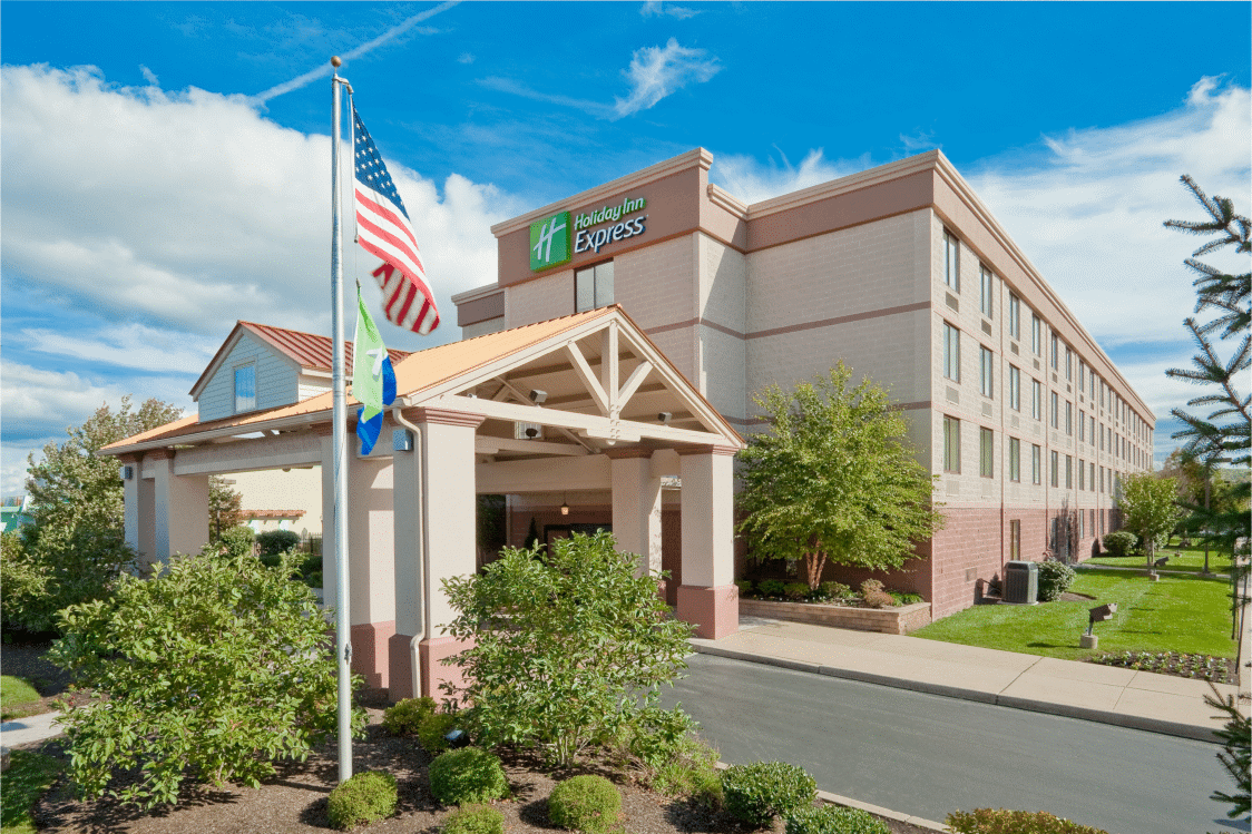
Holiday Inn Express - Exton - Lionville 120 N. Pottstown Pike Exton, PA 19341
Main: (610) 524-9000
MidwestGeo Rate: $129.00
- Location, Location, Location
- Easy campus access from the north
- Complimentary Wi-Fi
Terms and Conditions
Advance registration is necessary for participation in limited-enrollment short courses. Registration is on a first come, first served basis.
Pre-registration is required to reserve space and receive course materials.
Visitors are not permitted to access the classroom area.
A discount of 20% off each registration fee may be applied when five or more people from the same company register at the same time during the registration period.
A waiting list will be prepared of potential registrants when registration exceeds the allowable maximum. Twenty-five participants must be registered at the early registration deadline to conduct any course.
Early registration discounts may be applied when payment is received by the early registration deadline. If payment is not received by the early registration deadline, MidwestGeo reserves the right to remove your registration.
One substitute may be allowed for one registration in case the original registrant cannot attend.
No refunds for No-Shows.
Cancellations after Sept 5, 2018 of the course will be charged either (1) 50% of the course fee or (2) a credit may be applied for a future course.
We are glad to arrange for a special diet, equipment, or handicap facilities. We only ask that you let us know when registering for the course.
Misrepresentation of organization affiliation to access an exclusive discount for that organization is a breach of your registration agreement whereby having your registration removed or accepting full professional registration fee.
Members Login
Become A Member
It's Free, It's Easy and as a Member you'll enjoy...


 1.6 Continuing Education Units (CEUs)

 Martin Helmke is an accomplished hydrogeologist with over 20 years experience as an educator and environmental consultant. Before joining West Chester University, he taught at Dickinson College, Iowa State University, Antioch College, and Directed the Geology Field Camp for Iowa State University and University of Nebraska in Shell, Wyoming. He has worked for the U.S. Geological Survey (Reston, Virginia), Versar (Springfield, Virginia), HydroLog (Yellow Springs, Ohio), Boyden Caverns (Kings Canyon, California) and Aquadrill (Coralville, Iowa).
 Tim Kemmis is recognized for his multidisciplinary work in geology, pedology, and geotechnical engineering. Working as a research geologist at the Iowa and Illinois State Geological Surveys, he has conducted extensive research in glacial and fluvial sedimentology, geomorphology, stratigraphy, fractured tills, soil science, and sand-and-gravel aggregate resources. In the environmental industry he has worked for over 20 years as lead hydrogeologist and project manager. For the Midwest GeoSciences Group, Tim has conducted workshops and webinars on use and misuse of the Unified Soil Classification System, how to create boring logs that take the mystery out of the subsurface, and how to unravel complex glacial successions for environmental and engineering projects.
 Dave Hart is an accomplished hydrogeologist/geophysicist with the Wisconsin Geological and Natural History Survey and an associate professor at the University of Wisconsin-Extension.
 Katie is a civil engineer, a gINT trainer, and product manager for Bentley. She is an integral visionary with the gINT development team working to bring about the next generation of gINT.
 Dan Kelleher is a hydrogeologist recognized for this work in hydrogeological and geotechnical analysis of sedimentary sequences, aquifer testing, fractured rock hydrogeology, and predictive ground water modeling. Dan's business acumen promotes personal trust, integrity, and relentless QA/QC.