
DESIGNING AND OPTIMIZING GROUND WATER MONITORING SYSTEMS IN SEDIMENTARY SEQUENCES: PART 1: Deciphering Sedimentary Sequences and Targeting Meaningful Monitoring Units
Join us for this new three-part webinar series dedicated to designing and optimizing ground water monitoring systems in sedimentary sequences. Each part is 90-minutes and allows for 1.5 Professional Development Hours (PDH). You receive a copy of the webinar slides and a free Record of Attendance Form to distribute to participants at your computer site location.
Discover the key applications for effective well placement and ground water monitoring system design in sedimenary stratigraphic sequences. Application of design efficiencies will apply to glacial, alluvial, and fluvial sedimentary environments.
Learn ways to optimize your ground water monitoring system by:
- Eliminating redundant monitoring wells
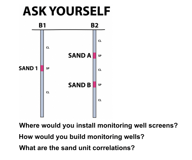
- Targeting laterally-continuous monitoring units and avoiding isolated sand lenses
- Avoiding invalid potentiometric surface maps
- Identifying meaningful monitoring units and placing effective wells
- Recognizing the water table in low permeable formations
- Making the right field observations and communicating them effectively
- Applying conditions from the case studies to your own scenarios and sites
The three-part series is presented in a step-wise process beginning with basic field testing and concluding with case studies of different sedimentary sequences to illustrate successes and failures of system design and optimization.
Register Now for this 3-part webinar series and learn to design ground water monitoring systems by installing properly-built wells in meaningful ground water monitoring units.
Part One begins with defining terms and philosophies. We will present some common problems that prevent us from efficient work and then provide options for solutions. We will examine different sedimentary sequences ranging from glacial to fluvial to gulf coast sediments for taking the mystery out of the subsurface and building a ground water monitoring system.
Part One also includes some Points to Ponder including the misuse of high-resolution sampling and misuse of the TRIAD sampling approach coupled with common misconceptions about mapping hydraulic conductivity and the consequences of basing monitoring system design on hydraulic conductivities alone.
We will conclude with the necessary information required to build a defensible ground water monitoring system that is efficient using a system that yields reproducible results.
Webinar Highlights:
- Introduction: Definitions and Common Challenges
- Hydrostratigraphy: Do's and Don'ts
- Misuse of High-Resolution Subsurface Sampling
- Fundamentals of geologic field analysis, boring correlations and targeting meaningful ground water monitoring units
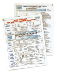
Register Now and receive a free
FIELD GUIDE FOR SOIL AND STRATIGRAPHIC ANALYSIS
for each site.
And, you may purchase additional field guides for a special discounted price of $10.00 plus shipping.
| Fee: |
299.00 USD Per Computer Site (unlimited participants per site)
Save $300.00 USD
when Members also register for BOTH of the following Webinars:


or Save $100.00 USD
when Members also register for EITHER of the above Webinars
(discounts will be applied during checkout based on your cart contents)
Pay one site registration fee and an unlimited number of participants from your organization can attend at that site.
|
| Instructor: |
David J. Hart, PhD and Daniel Kelleher, PG, CIPM |
| Handouts: |
Copy of Webinar Slides (pdf)
Record of Attendance Form (pdf)
|
| Duration: |
1.5 hour plus Q&A
(no restrictions on time limit for extra Q&A!)
|
Professional
Development: |
Earn 1.5 Professional Development Hours (1.5 PDH)
 |
A Record of Attendance Form is included free with each webinar for your record keeping and individual PDH verification. We ask your on-site coordinator to return the completed and signed copy of the Form to us following the webinar for (1) maintaining a separate copy as a service to attendees and (2) forwarding to NIU confirming attendance for those who order certificates.
Attendees may also order an official a Course Completion Certificate from Northern Illinois University for a small administrative fee. The Certificate is optional and may be ordered separately following the webinar to confirm your attendance and showcase the certificate on your office wall. Instructions for ordering certificates are given during the webinar.

* This webinar is eligible for the 'BUY THREE, GET THREE' discount; however ANY webinar series discount shown above cannot be combined with it.
Attendees will be invited to actively participate during this live and interactive on-line web seminar. Discussion is planned following the webinar for those who want to continue the session. Bring your questions to the webinar and present them to the instructor and other participants for exploring the best solution.
Instructors Bio
Dave Hart, PhD, PG
 Dave Hart is a hydrogeologist/geophysicist with the Wisconsin Geological and Natural History Survey and an associate professor at the University of Wisconsin-Extension.
Dave's applied research includes regional groundwater flow and recharge in southeastern Wisconsin, near-surface geophysics, and measurement of porosities and permeabilities in aquifers and aquitards. Prior to joining the university, he served as a hydrogeologist with Eder Associates. He is an associate editor for Ground Water and past president of the AWRA - Wisconsin Section.
Dan Kelleher, PG, CIPM
 Dan Kelleher is a hydrogeologist who strives for excellence in subsurface characterization. Dan earned his bachelor's degree from Monmouth College and master's degree at Northern Illinois University. His technical expertise is quantitative hydrogeology (in porous and fractured media), geotechnical analysis of sedimentary sequences, aquifer testing and predictive ground water modeling. He promotes field analysis during stratigraphic characterization from boring to boring in order to utilize QA/QC processes fully throughout a project and help identify unexpected conditions as soon as they arise.


