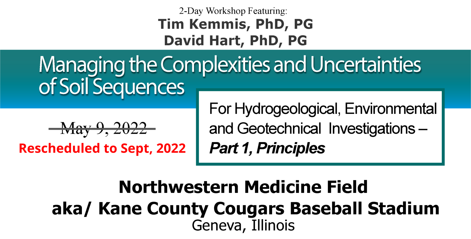
Managing the Complexities and Uncertainties of Soil Sequences: For Hydrogeologic, Environmental, and Geotechnical Investigations - Part 1, Principles
Date:
Monday, May 9, 2022 September, 2022
Location:
Northwestern Medicine Field (aka/ Kane County Cougars Baseball Stadium) - Conference Facility and Suites
Instructors:
• Tim Kemmis, PG, PhD, Hydrogeologist with Midwest GeoSciences Group
• David Hart, PG, PhD, Program Leader, Hydrogeologist, Wisconsin Geological and Natural History Survey
Workshops Featuring:
Role of Geologic Principles Merits and Mis-Use of Hydrostratigraphy Measuring Aquitard Integrity Diagnostic Plots of Hydraulic Head Profiles Differentiating Uncertainty from Variability Managing Unanticipated Site Conditions
Continuing Education Information:
0.8 Continuing Education Units (CEUs) (8.0 Professional Development Hours)
Continuing Education Units (CEUs) and a Course Completion Certificate will be administered by the Northern Illinois University. Most state professional licensure programs accept CEUs for this course.
PRE-APPROVED FOR: Connecticut Licensed Environmental Professionals (Course ID: CT-LEP 443) Massachusetts Licensed Site Professionals (Course ID: MA-LSP 1606) Delaware Professional Geologists South Carolina Professional Geologists (Course No. SCPG # 1927) New Jersey Licensed Site Remediation Professionals (Course 2017-043)
Who should attend:
Professional ground-water scientists, engineers, project managers, compliance-program managers and remedial-design managers characterize complex soil sequences, relate geotechnical properties to the site-specific soils, understand groundwater flow through the sequences, and install dependable groundwater monitoring systems.
How to Prepare:
Be prepared to immediately dive into a series of lectures, workshops and self-tests that are designed to help empower you unravel subsurface complexities like no other course. We start at the beginning and boldly address the challenges we all face in our profession...and then move into principles and strategies for managing subsurface uncertainties for ground water and geotechnical projects.
Bring your curiosity to learn and writing materials. There is no field component to this course (this is a separate from course, Field Techniques).
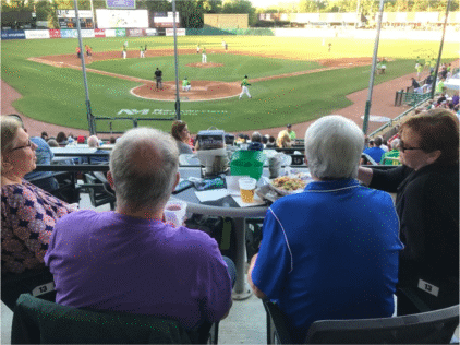
FOR THOSE WHO REGISTER FOR THE OTHER COURSE: PART TWO - FIELD TECHNIQUES YOU'RE INVITED TO THE BASEBALL GAME TOO
Plus, on Tuesday 10 May, the Kane County Cougars Baseball Team will be playing their first exhibition home game against the Gary SouthShore RailCats. Participants are invited to access the stadium early - directly following the course sessions - and stay as special guests of our beloved Kane County Cougars! (This is complimentary access as a gesture from our venue host).
Course Details
Why You Want to Attend:
This 8-hour classroom course begins a landmark training experience.
This classroom course teaches the hydrogeologic principles for applying depositional environments and the effects of secondary weathering to characterizing ground water movement, contaminant migration, and geotechnical properties.
The measurable outcomes of this course experience is the having the abilities to apply these principles to (1) our understanding subsurface relationships, (2) recognizing the important components of stratigraphy, (3) documenting our observations by creating meaningful soil boring logs, and (4) Taking the Mystery Out of the Subsurface ®.
This one-day training experience is designed for every skill level. A basic geology and hydrogeology background is more than helpful.
Applying Basic Geologic Principles to Solve Complex Issues
A proven field strategy for managing complex sedimentary sequences begins with applying basic geologic principles. Field staff are often busy with field screening or collecting environmental samples and/or sometimes just not equipped or experienced to recognize key indicators for meaningful subsurface characterization.
This course features a comprehensive review of applied geologic principles about depositional processes and post-depositional effects and how they are applied to ground water monitoring and contaminant transport.
Thinking in the Field and Preparing Meaningful Boring Logs
State-of-the-industry boring log descriptions provide useful information, but often are insufficient for providing the critical information project engineers and hydrogeologists need. Field techniques such as recognizing key beds or attributes can help unravel complexities.
This workshop presents helpful techniques for quickly and accurately classifying soils and simple enhancements to boring logs that will take the mystery out of the subsurface.
Making Sound Field Decisions
Field conditions are sometimes not what we expect to find. For those moments it helps to have staff who are willing and capable of knowing what questions to ask, when to ask them, and make sound field decisions. This 8-hour course is designed to empower professionals to recognize unanticipated site conditions and manage them in a logical and reliable way.
Managing Uncertainty and Unanticipated Conditions
Uncertainty is the not the same thing as variability. You may be certain of the subsurface variability and that allows you to prioritize data gaps and assess the need for more or less certainty.
Uncertainties and unanticipated conditions are frequently encountered while investigating complex soil sequences. This course includes a session devoted specifically to recognizing and managing these unanticipated conditions and uncertainties, including how to avoid the misuse of some principles and techniques.
This is the only course that teaches the principles of how depositional environments and weathering zones play a role in hydrogeologic and geotechnical investigations.
Get more from your existing borings instead of always wanting more.
Registration
REGISTRATION INFORMATION:
Limited to 50 registrants.
Advanced registration is necessary for participation in this limited-enrollment short course. Pre-registration is required to reserve space and receive course materials. If you require special arrangements for diet, equipment, or handicap facilities, please indicate when registering for the course.
Register online for this course.
WHAT YOU WILL RECEIVE:
Participants receive 8.0 contact hours of instruction, a Course Notebook, a FIELD GUIDE FOR SOIL AND STRATIGRAPHIC ANALYSIS, course completion certificate from Northern Illinois University, light breakfast items and morning coffee, lunch, and an afternoon break.
Plus, following the course, each participant will receive the final soil boring log and brief report that is associated with drilling in the other course, Field Techniques.
This course is in collaboration with AEG Chicago Chapter and it's awesome membership. Midwest GeoSciences Group is giving the AEG Chicago Chapter an appreciable portion of the proceeds of this training experience. There is an incentive for AEG Members to register that benefit them individually and for the chapter: Click Here to read about it.
FREE FIELD GUIDE FOR SOIL AND STRATIGRAPHIC ANALYSIS with each course registration.
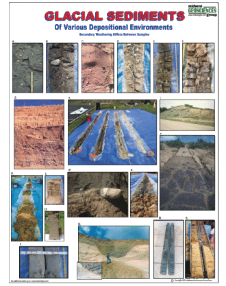
FREE NEW FOR 2022! GLACIAL DEPOSITS CHART when you register for both Part 1 and Part 2 of this course.
OPTIONAL ITEMS:
The online registration allows registrants to add items to their course registration.
Item No 1: Full-Color Printed Notebook for $89.00.
EARLY REGISTRATION DISCOUNT:
Early registration discounts may be applied when payment is received before August 31, 2022. Terms and Conditions apply.
CANCELLATIONS:
Cancellations may be made up to September 1, 2022, however, 50 percent of the course fee will be charged or a credit will be issued. No refunds. One substitute is allowed for each registrant who is unable to attend.
QUESTIONS:
Technical Questions: For registration and technical questions about the course, contact Dan Kelleher at either 763.607.0092 or dan@midwestgeo.com
* Final Number of accepted registrants may change due to space requirements and restrictions.
Instructors
Tim Kemmis, PhD, PG and David Hart, PhD, PG
Tim Kemmis, PhD, PG
Tim Kemmis is an accomplished Hydrogeologist who is internationally-recognized for his applied research in depositional environments and associated characterization of sedimentary facies and stratigraphic relationships.
Tim received his bachelor's degree in soil science from the University of Illinois and was promptly drafted into the U.S. Army where he was trained basically to be a geotechnical lab technician, performing soil classification and testing.
Returning to the University of Illinois after the Army, Tim did his master's degree in glacial geology while working as a graduate assistant at the Illinois State Geological Survey. Tim's research focused on depositional processes and the resulting stratigraphic relationships.
From there, he worked 14 years for the Iowa Geological Survey, during which he received his Ph.D., and where he:
Established the formal glacial stratigraphy for the Des Moines Glacial lobe based on depositional environments
Determined the geometry and origin of jointing in glacial tills
Developed a lithofacies code to decipher the history of glacial outwash and alluvial sequences
Then in the 1990's, Tim was recruited by a large environmental and engineering consulting company where for most of time since then, he has worked as a senior consulting hydrogeologist and project manager for large-scale hydrogeologic investigations.
Tim Kemmis has established sedimentary and stratigraphic frameworks at sites located around the world. He has refined regional and local geologic frameworks across the United States that are today used by state geological surveys.
Tim is uniquely qualified and has (20+) years of teaching about how sedimentary processes relate to stratigraphy and the ground water flow regime. Because of Tim's unique perspective from both his research and consulting experience, he has assembled a practical and applied process for subsurface characterization that begins with accurate and complete soil descriptions.
Tim Kemmis has published numerous professional research papers and journal articles and has contributed to the leading research about glacial depositional environments. With Midwest GeoSciences Group, he's a co-founder along with a lead instructor for "Taking the Mystery Out of the Subsurface 2.0" and Hydrogeology of Glacial Deposits, and a co-author of the FIELD GUIDE FOR SOIL AND STRATRIGRAPHIC ANALYSIS.
David Hart, PhD, PG
Dave Hart is an accomplished hydrogeologist/geophysicist with the Wisconsin Geological and Natural History Survey and an associate professor at the University of Wisconsin-Extension.
Dave's research is applied hydrogeologic science that serves local and state government, private citizens, and other interested parties, such as planning commissions and environmental consultants. His technical work includes hydrogeology, near-surface geophysics, and physical properties of geologic materials. His areas of research include wellhead protection, water use, the application of near-surface geophysics to geologic and hydrogeologic problems, development of techniques to understand the role of aquitards in flow systems, measuring flows in boreholes, and incorporating geology into the design of geothermal heat pump systems.
Dave is recognized for groundwater education designed for professionals internationally through Midwest GeoSciences Group and also university students across the United States. Dave is also a dynamic instructor for teaching teachers who want to learn to use an interactive groundwater model to demonstrate concepts such as flow through various types of materials.
Prior to joining the university, Dave worked as a hydrogeologist with Eder Associates.
Dave has numerous publications and professional reports with the WGNHS. Dave is also a co-author on the two-part book published by AWWA and pertinent to this online course, Assessment of Contaminant Transport Through Aquitards - Part A and B: "State of the Science" Report.
He is an associate editor for Ground Water and past president of the AWRA - Wisconsin Section. He is the recipient of the Marquee Webinar Instructor Award from Midwest GeoSciences Group. Dave is also a co-instructor with Tim Kemmis during the online course: Hydrogeology of Glacial Deposits, the webinar series, Designing and Optimizing Ground Water Monitoring System in Sedimentary Sequences, and the webinar series Hydrogeology of Aquitards and Low-Permeability Materials.
Two Course Advantage
What makes this particular training experience remarkable?
No other training combines the PRINICPLES with PRACTICE, like this one.
The soil core and sedimentary sequence is EXQUISITE for teaching.
There is no substitute for synthesizing the sedimentary record from a boring. It's a skill that takes time to develop, a coach for teaching the skills, the right tools, and a willingness and capability to perform. Without the right direction to start with, we can get lost by confusing standards, mixed messages, and conflicting technical priorities.
This course addresses all of it.
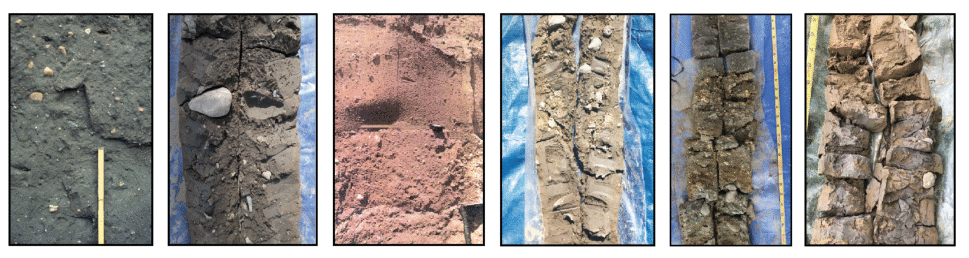
The soil boring presents an unmatched opportunity for teaching the application of geologic principles. Understanding the PRINCIPLES allows us to apply our geoscience knowledge to decipher the subsurface in an efficient and effective way. What makes this unique soil boring so excellent is we will directly observe:
Different glacial environments (subglacial and ice-marginal).
Different outwash environments (glaciofluvial and glaciolacustine).
The progressive weathering sequence from the ground surface.
A buried soil and weathering zone.
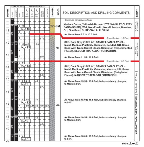
This single soil boring is an exquisite sedimentary record for understanding the importance of stratigraphy to professional projects. We are doing to dissect the soil boring from top to bottom in the same way a doctor examines a patient.
Part One - Principles starts at the beginning with broad conceptual approaches for deciphering the subsurface. It quickly advances to applying geologic principals to hydrogeologic, environmental, and engineering projects. Sometimes we make our work more difficult than it needs to be but understanding the PRINCIPLES allow us to approach the subsurface in a rationale way. With this knowledge of principles, we can take steps in creating efficiencies and make sound field decisions. This sets that stage for what's to come in Part Two - Field Techniques.
Part Two - Field Techniques applies geologic principles to what we do in the field. This training goes far beyond improving soil boring logs, it's a gigantic leap toward recognizing the stratigraphy and synthesizing it for a realistic and reliable Conceptual Site Models. The field techniques learned in this course couplet will help unravel the complexities and uncertainties from sedimentary successions that is used for:
Establishing site stratigraphic units.
Correlating buried units with certainty and confidence in the field.
Understanding subsurface relationships.
Modeling vertical seepage rates and horizontal ground water movement.
Designing ground water monitoring systems.
Building a credible ground water flow model.
Creating a realistic remediation strategy.
Collecting soil samples that are rational to stratigraphy.
Testing sediment that is diagnostic to project objectives.
Participants will benefit from the years we've been teaching these courses.
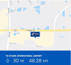
Venue and Accommodations
CLASSROOM
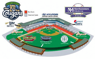
Northwestern Medicine Field (aka/ Kane County Cougars Baseball Stadium) Conference Facility and Suites
34W002 Cherry Lane
Geneva, IL 60134
Directions to the Stadium
From I-88: Take I-88 to the Farnsworth Ave. exit, proceed north approximately 5 miles and turn left onto Cherry Lane.
Alternate Route from I-88: You may also exit at Route 59 North or Eola Road North and proceed to Butterfield Road. Follow west to Farnsworth Ave./Kirk Road and turn left onto Cherry Lane.
From I-90: Take I-90 to Route 59 South, to Route 64 West to Kirk Road. Travel approximately three miles south and turn right onto Cherry Lane.
From I-290: Take I-290 to I-88. Follow along I-88 West and exit at Farnsworth Ave. North. Proceed approximately five miles north and turn left onto Cherry Lane.
Cherry Lane is the ONLY access to the Cougars parking lot.
Advance registration is necessary for participation in limited-enrollment short courses and workshops. Registration is on a first come, first served basis.
Pre-registration is required to reserve space and receive course materials.
Safety is paramount. Each participant is responsible for his/her own safety and agrees to help keep all other participants safe. No harassing behavior or intimidation is acceptable. Midwest GeoSciences Group, Northern Illinois University, and Kane County Cougar Baseball Stadium staff want all participants to feel comfortable during our events.
Visitors are not permitted to access the classroom or field workshop areas.
A LIABILITY WAIVER is required to be accepted and signed by each participant in all events. The LIABILITY WAIVER is sent via email to all registrants on or about September 1, 2022 and required to be returned to Midwest GeoSciences Group on or before September 14, 2022.
A waiting list is prepared of potential registrants when registration exceeds the allowable maximum. Twenty-five participants must be registered at the early registration deadline to conduct any course.
Early registration discounts may be applied when payment is received by the early registration deadline. If payment is not received by the early registration deadline, MidwestGeo reserves the right to remove your registration.
One substitute may be allowed for one registration in case the original registrant cannot attend. This applies to full registrations, not split between courses.
No refunds for No-Shows.
Cancellations may be made up to September 1, 2022, however, 50 percent of the course fee will be charged or a credit will be issued. No refunds after September 1, 2022. Refunds are issued after the course is conducted.
COVID: Participants to the event agree to follow the COVID-19 Precautions set forth by the Venue. Participants will be provided written precautions at the time of the Liability Release. The latest COVID-19 Precautions by the venue can be found here.
We are glad to arrange for a special diet, equipment, or handicap facilities. We only ask that you let us know when registering for the course.
Misrepresentation of organization affiliation to access an exclusive discount for that organization is a breach of your registration agreement whereby having your registration removed and payment forfeited or accepting full professional registration fee.
For AEG Members
It's true. Midwest GeoSciences Group appreciates AEG and it's membership. For this reason we are donating a portion of the proceeds of the course registration revenue to AEG Chicago Chapter.
Plus, the first 10 paid AEG members who register for this course using Promo Code- SOIL2022-AEG -will receive a MIDWESTGEO SOIL EXAM KIT (Beta Version with five samples). Each of the five samples are lab calibrated and classified according to five different classification systems: (1) USCS, (2) USDA, (3) Burmeister, (4) Wentworth, and (5) AASHTO. Kits will be distributed at the course.
It's just our way of saying Thank You. -Dan Kelleher.
AEG members must be active AEG membership to use the Promo Code and receive the discount. Terms and Conditions Apply.
Members Login
Become A Member
It's Free, It's Easy and as a Member you'll enjoy...


 FOR THOSE WHO REGISTER FOR THE OTHER COURSE: PART TWO - FIELD TECHNIQUES