Some questions and answers
about the SOIL CLASSIFICATION EXAM KIT.
What soil classification procedure is appropriate?
The appropriate procedures are dictated by your company's project objectives and requirements along with associated Standard Operating Procedures.
Each of the samples are classified according to the following references:
USCS:
ASTM D2488-00, Standard Practice For Description And Identification Of Soils (Visual-Manual Procedure); ASTM D2487-17, Standard Practice for Classification of Soils for Engineering Purposes (Unified Soil Classification System), updated April 2020.
or
FIELD GUIDE FOR SOIL AND STRATIGRAPHIC ANALYSIS v.2 by Midwest GeoSciences Group
USDA:
Schoeneberger, P.J., D.A. Wysocki, E.C. Benham, and Soil Survey Staff. 2012 (REPRINTED 2021). Field book for describing and sampling soils, Version 3.0. Natural Resources Conservation Service, National Soil Survey Center, Lincoln, NE.; this procedure references the original textural triangle published first in: USDA Soil Survey Staff. 1951. Soil Survey Manual. USDA Handbook No. 18.
or
USDA SOIL TEXTURING FIELD FLOW CHART by Midwest GeoSciences Group
AASHTO:
AASHTO M 145 : Standard Specification for Classification of Soils and Soil-Aggregate Mixtures for Highway Construction Purposes; American Association of State Highway and Transportation Officials.
Wentworth:
Chester K. Wentworth, 1922, The Journal of Geology: "A Scale of Grade and Class Terms for Clastic Sediments"
(You can apply your own classification scheme (ex, Shepard, Folk, or others) using the Wentworth Scale.)
Burmister:
D. M. Burmister, 1949, "Principles and Techniques of Soil Identification" 29th Highway Research Board Proceedings.
(Note that several modifications to the Burmister System have occurred in the past 25 years. The testing and coding for these samples are assigned from the classic Burmister procedures).
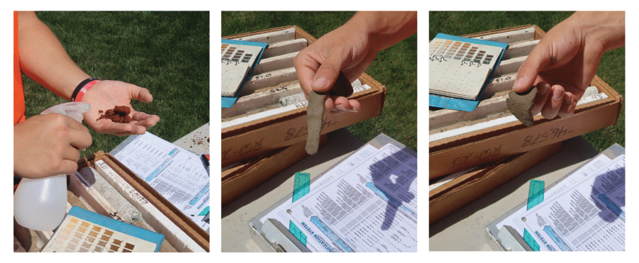 Optimizing moisture to create ribbons and feel plasticity
Sample Quiz question from the General Questions Quiz:
Standard Operating Procedures with common methods ensure:
- Work processes are communicated as a common language for everyone.
- QA/QC is achievable.
- Deviations of the work process are detectable.
- Are intended to promote best practices.
- All of the above.
Did you choose answer E?
If you want to learn more about the role of soil classifications in deciphering sedimentary sequences and stratigraphy, then consider these three online training options:
Boring Log Basics: Fundamentals for Preparing Soil Boring Logs (90 minute webinar)
or
Taking the Mystery Out of the Subsurface (8.0 hour online course)
or
The Challenges and Strategies for Implementing Environmental Sequence Stratigraphy
(8.0 hour online course)
What is the most common soil classification system for environmental and engineering projects in the United States?
The Unified Soil Classification System (USCS).
Each sample in the SOIL CLASSIFICATION EXAM KIT is based on common variations of the USCS. The samples chosen for this kit are based on skill development/mastery for baseline USCS classifications.
For example, grain size plays a role in our visual estimation of soil classifications. Some of the samples in the kit may be the same USCS Group Name and Symbol, but they are different based on grain size of the coarse-grained fraction (Imagine the powerful learning moment when we discover how grain size influences our field estimation by feel and visual observations.)
Sample Quiz question from the online USCS Quiz:
The purpose of the Unified Soil Classification System (USCS) is to:
- Serve as a surrogate for stratigraphy.
- Classify the soil according to grain size and plastic properties.
- Characterize the variability or uniformity within a site stratigraphic unit.
- Help decipher depositional environments.
Did you choose answer B?
Soil classifications are important, and they provide the common language between professionals about soil types and properties. They are not a surrogate for stratigraphy or a substitute for defining either subsurface units or depositional environments. This rule applies to all soil classification systems.
Why is volumetric estimation vs. dry weight estimation important?
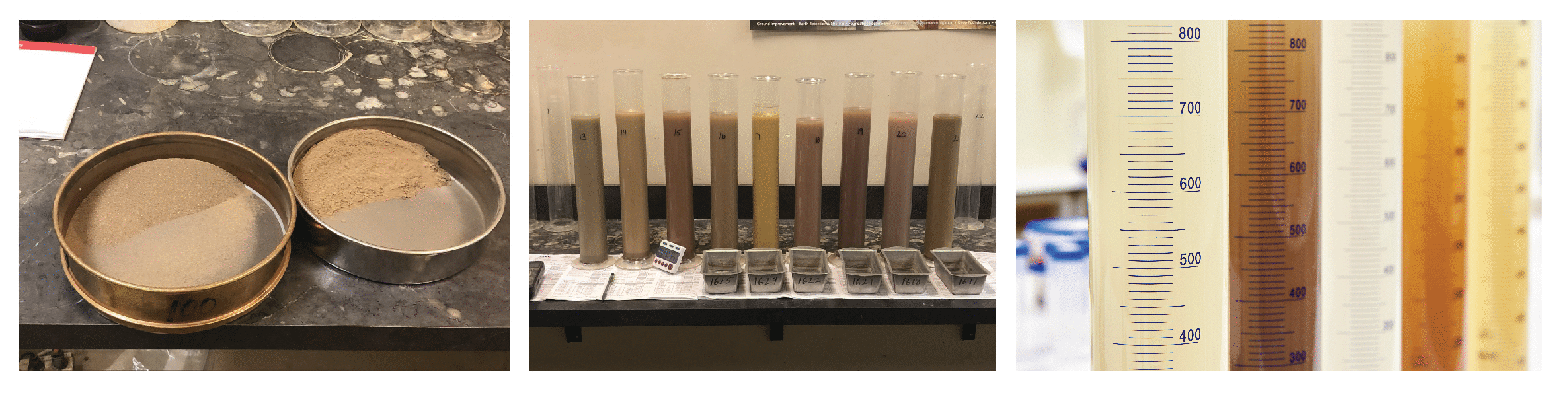
Most of us learn soil classification using a visual volumetric estimation between fine-grained and coarse-grained portions. However, classifications are based on dry weights of the total sample. Not only is this important to understand and apply in the field, it's neither intuitive or simple.
If you practice your field soil classification skills using laboratory results (following the field project), then you're aware of the difficulty with accurate estimation of coarse-grained fraction based on dry weight, not to mention the challenges from tricky variations due to particle size.
Some people apply the jar method where a pulverized soil sample is allowed to settle in a jar of water. The soil samples in this kit will reveal when we can rely on that technique, and when we can't rely on it.
How can the soil classifications be compared if the grain size boundaries are different?
Each soil sample only has one particle size curve. Soil classification systems define classifications differently and use different particle size boundaries as shown by the laboratory data sheets contained in this soil exam kit.
For example, the boundary for SAND between the USCS vs. USDA is different. The USCS lower boundary is 74 microns (0.029 in. / 0.074mm) and the lower boundary using the USDA for sand is 50 microns (0.00196 in. / 0.05mm).
Automatic correlation of soil types between classification systems is a myth. For example, not all USCS classifications of "LEAN CLAY WITH SAND (CL)" are the USDA texture "LOAM". Clay mineralogy plays an appreciable role during USCS classifications due to the variability of plastic properties of fine-grained classifications; this soil kit reveals part of that process.
How much sample is contained in each jar?
Each sample volume is about 2 ounces. If you were looking at a soil core sample, that equates to about 2 inches long within a GeoProbe ® Macro-Core (MC5) Sampler or about 2.5 inches long within a SPT split-spoon sampler.
It's more than sufficient volume to: (1) form a 2 cm diameter ball of cohesive sediment and feel the plastic or non-plastic nature of a sample, or (2) visually inspect the uniform/non-uniform nature of the granular sediment samples, and (3) observe the coarse-grained fraction in a fine-grained sediment.
Is it SILTY SAND (SM) or SANDY SILT (ML)?
This kit clearly reveals the answer. Samples contained in this kit plot on each side of that important boundary for the USCS, but you are required to identify it for yourself as part of the exam. Then the answers for each jar sample are provided online when you're ready to reveal for yourself the classifications to the SOIL CLASSIFICATION EXAM KIT.
 Lab data sheets are included in answer key of all classifications for every sample
Return to main webpage for SOIL CLASSIFICATION EXAM KIT


