On-Demand Webinars
Post-Depositional Weathering of Glacial Deposits:
Understanding the Development and Effects of
Weathering Zones and Secondary Jointing
|
Surficial weathering alters the geotechnical and hydrogeologic properties of glacial sediments. South of the Canadian Shield, where glacial deposits are derived from Paleozoic and younger sedimentary bedrock, distinctive weathering patterns and weathering zones develop from the surface downward.
Surficial soils develop from the land surface downward and are commonly 0.5 to 2 m (1.5 to 6 feet) thick. Alteration is so great that these surficial soils have a pervasive secondary soil structure that largely obliterates any primary sedimentary structure.
Beneath the surficial soils, weathering continues but is not as intensive, and a sequence of "weathering zones" develop. Weathering zones and secondary jointing in fine-grained sediments is among the most important subsurface attributes for hydrogeologic, environmental and geotechnical projects, effecting:
- Permeability, both primary and secondary
- Water Table
- Jointing and Fracturing in Fine-Grained Sediments
- Drainage
- Strength, Compaction, Density/Consistency
- Contamination
- Stratigraphy and Facies Changes
|

|
The sequence and depth of these weathering zones indicate the nature and extent of the subsurface alteration that these deposits have undergone. Weathering zones can be quickly and readily described using simple letter abbreviations, and are extremely important in recognizing vertical facies changes and the potential for jointing at depth in the glacial succession.
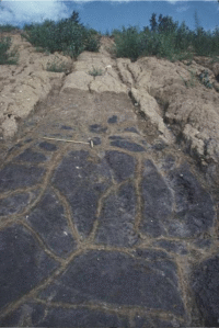
Accompanying weathering is the development of secondary jointing: fractures that affect infiltration and sediment strength. Examination of fracture geometry indicates that they develop from desiccation. The desiccation process significantly affects the hydraulic conductivity of fine-grained glacial deposits.
Professionals rarely get a chance to learn about the importance of weathering zones and jointing in glacial deposits - this webinar series is designed for hydrogeologic, environmental, and engineering professional who can benefit and improve project results by discovering how to understand some of the most important site characterization attributes.

See what others are saying...
"The (9-hour Hydrogeology of Glacial Deposits) online course offers a whole new way of understanding and evaluating till deposits, based on their depositional environments. It's refreshing to see the recent progress in this field."
- Lance Kazzi, LEP, Principal Geologist, Arcadis U.S., Inc.
"First let me say that I found the webinars very interesting and pertinent.
It was easy to navigate through the purchase and viewing of the webinars. Finally, the turn-around time for receiving the Certificates of Completion was phenomenal. I was able to get the paperwork to the State on time and therefore renew my license.
Thank you for all your help. I will be looking at Midwest Geosciences Group courses in the future. I hope you will get more approved for CT LEP credit. I also look forward to the opportunity to take one of your field courses. Thank you again."
- Daniel E. White, LEP, Mountain Laurel Environmental, LLC
Instructors Bio
Tim Kemmis, PhD, PG
 Tim Kemmis, PhD, PG is a Senior Hydrogeology Consultant and Project Manager for large-scale hydrogeologic investigations. His unique experience as both an applied researcher and consultant has enabled Tim to effectively teach staff at all levels how unravel sedimentary complexities by making fundamentally sound observations, preparing complete and accurate boring logs and confidently correlating geologic units. Tim Kemmis, PhD, PG is a Senior Hydrogeology Consultant and Project Manager for large-scale hydrogeologic investigations. His unique experience as both an applied researcher and consultant has enabled Tim to effectively teach staff at all levels how unravel sedimentary complexities by making fundamentally sound observations, preparing complete and accurate boring logs and confidently correlating geologic units.
Tim received his bachelor's degree in agricultural soil science from the University of Illinois and his master's degree in glacial geology while working as a graduate assistant at the Illinois State Geological Survey.
He worked 14 years for the Iowa Geological Survey, during which he received his Ph.D., and where he:
- Carried out glacial sedimentologic investigations
- Remapped the Des Moines Glacial lobe
- Established the formal glacial stratigraphy for the lobe based on depositional environments
- Discovered a new type of hummocky glacial topography
- Determined the geometry and origin of jointing in glacial tills
- Developed a lithofacies code to decipher the history of glacial outwash and alluvial sequences
Tim is a co-founder of Midwest GeoSciences Group and has successfully taught many courses and webinars dedicated to improving boring logs and helping geologists think on their feet.
| Fee: |
249.00 USD Per Webinar
|
| |
You're SAVING $50 USD just for being a Member
|
| Materials and Downloads: |
Session Slides (PDF)
Additional Materials- Exercise Boring Log Review
- Alternate Session Slides (larger images)
Record of Attendance Form (PDF)
|
Number of
Participants: |
As of June 1, 2020, online training is designed and priced for individuals working alone.
|
Continuing
Education
Certificates: |
$14.95 each. Official CEU certificates are available as an option. After successful completion of this webinar, a link will be provided to order a certificate from Northern Illinois University.
|
| Access: |
On-demand, anytime 24/7. |
| Discounts: |
Buy 3 on-demand webinars, and get 3 on-demand webinars for free!
|
| Duration: |
120 minutes |
| PDH Earned: |
2.0 hours |
| MA LSP: |
2.0 hours (MA LSP No. 1710) |
| CT LEP: |
2.0 hours (part of CT LEP-491E) |
| |
|
| Instructor(s): |
Tim Kemmis, PhD, PG |
|
Become A Member
It's Free, It's Easy and as a
Member you'll enjoy...
- Exclusive Videos
- Special Pricing
- And Much More
|
|
Join
|
Learn More
|
Association of Environmental
& Engineering Geologists
|


